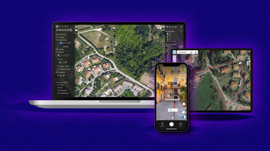
Take advantages of fast and accurate indoor and outdoor data acquisition at any scale, with common low-cost devices.
End-To-End Platform
Manage and monitor asset networks both on-field and remotely throughout their life-cycle.
Innovative
3D-Centric Interactions
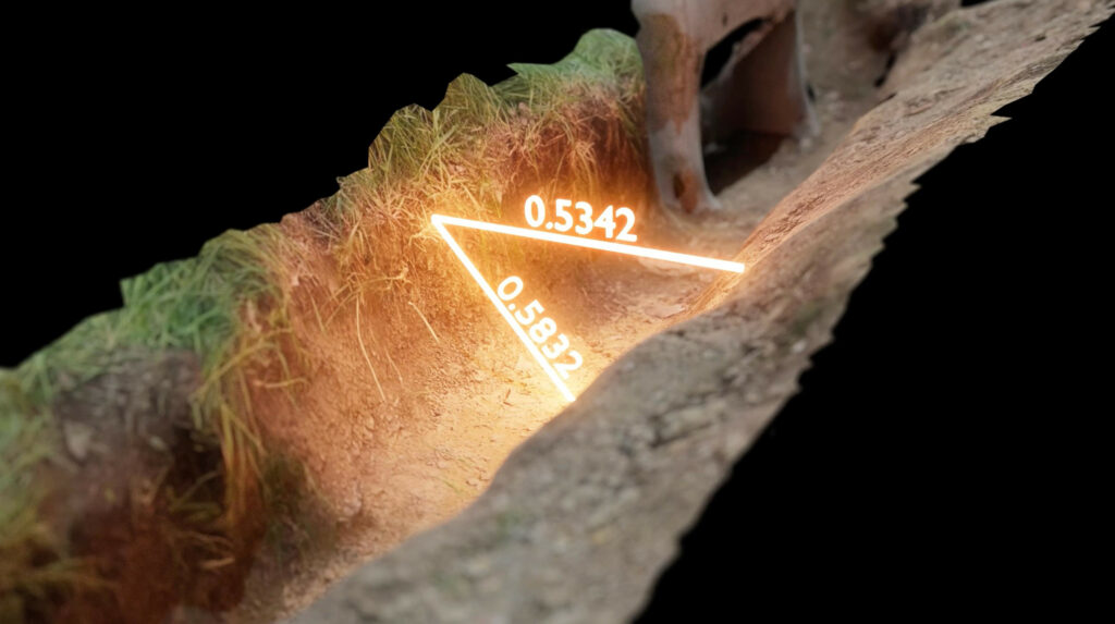
Know your infrastructure in detail, interacting and analyzing it through 3D models, 360 images, AR visualizations and AI automation.
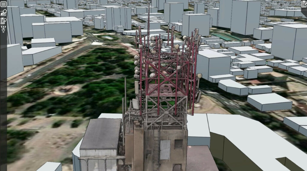
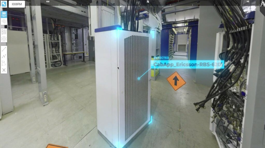
Cell Tower - AI
Looking to reduce cell tower management costs?
Our SaaS solution provide a geo-referenced digital twin of your assets, from telco trellis and antennas to equipment rooms, enabling remote inspections, automatic damage detections and a set of innovative tools that minimize operational time and costs.
Interested in optimizing fiber optic-related job activities?
The 3D4U’s FTTx package enables to efficiently carry out indoor and outdoor field surveys, make outline forecast, design structural and optical schemes in 2D and 3D and monitor construction sites from the office.
Unlocking efficiency and growth: Explore 3D4U transformative benefits
Say no to expensive software that requires a significant investment.
Implement in the company ecosystem a single multi-solution platform compatible with low-budget smartphones. Make the most out of current business devices and use advanced tools at your fingertips, avoiding high acquisition costs while ensuring high quality.
Steer clear of complicated systems that slow down your work
Get the 3D model in almost real-time, in no more than a day. Whether you are an expert or new to the field, don’t worry — we provide comprehensive knowledge and consulting services to help you succeed.
No more costly and time-consuming unnecessary field trips.
Digitalization gives you the freedom to work remotely. Monitor and assess your infrastructural elements wherever you are to take informed decisions, while minimizing risks, decreasing C02 emissions and reducing operational costs up to 40%.
Forget IT configuration headache. No LIDAR is required.
Thanks to our flexible cloud-based cross-platform system, 3D4U operates on multiple browsers and mobile operating systems (iOS and Android), with or without LIDAR sensors, avoiding investing in new costly business equipment.
Not another complex platform for technical people.
Our system makes it possible to easily manage a large asset network that is spread geographically, regardless of the technical expertise of the user. Its quick and stress-free integration into everyday operations is based on a zero-friction methodology and an intuitive user interface.
Stop relying on outdated solutions that keep you wasting precious time.
Unlock the power of advanced technologies such as ML, AI, AR, etc and streamline your work. Run reliable estimations, automate database enrichment and early damages recognition and export reports and project files with a click, to always be ahead of competitors.
“You don’t need an expensive tool to make data acquisitions, just grab your phone and you’re done“
“Create your digital twin stress-free with the best cost-benefit platform and stay ahead of the competition.“
“Optimize infrastructure management of dispersed assets in a single easy-to-use GIS environment and take fast data-driven decisions to increase business growth.“
“Reduce unnecessary work trips and risks through remote asset inspection and save up to 45% of operational costs“
Key features of your end-to-end Solution for Efficient Infrastructure Design, Inspection, and Maintenance in a Unified Digital Environment
Comprehensive Digital Twin Solution
Enabling the acquisition, digitization, and visualization of all infrastructure assets in one environment to create a complete digital twin, including towers, equipment rooms, cabins, shelters, and the entire supporting ecosystem.
Whether you’re a tech enthusiast, industry professional, or simply curious about the future of technology, check out our blogs, join us to explore new trends, and stay tuned for expert opinions, success stories, and much more!
SUCCESS STORY
The Digital Twin for the implementation of Fiber Optic Networks
The general goal of the customer was to make the activities related to the implementation of the fiber optic infrastructure more efficient, avoiding frequent business trips and objectively accounting for the progress of the works under the responsibility of the external supplier, while speeding up the operational flows related to the network creation.
The Digital Twin for Monitoring Distributed Wireless Infrastructures
The customers, major companies active in the national and international transmission infrastructure markets, needed to innovate their operational methodologies and IT systems for monitoring their networks, to have a more comprehensive overview of the infrastructure’s health status and to adopt leaner and faster processes.
Are you interested in using 3D4U for your professional domains?
The SaaS solution is applicable across a diverse range of industries including architecture, manufacturing, transport, smart cities, energy and much more.
Oil & Gas
Asset Management and HSE Compliance Elevate the safety, efficiency, and reliability of your operations. Find out how to enhance maintenance practices, improve HSE standards, and remain competitive in the product market.
Energy & Utilities
Deliver safe, uninterrupted energy and utilities while creating efficient, reliable, and sustainable utility operations. Calculate potential impacts on the grid, monitor asset health, anticipate failures, and plan maintenance procedures effectively.
Manufacturing
Improve manufacturing reliability and performance, kickstart your Industry 4.0 transformation, optimize manufacturing assets, and reduce defects and downtime. Discover how you can create more sustainable operations.
Buildings & Cultural Heritage
Developing and implementing an advanced IoT architecture for data-driven smart building operations and experimentation, specifically designed for cultural heritage preservation and other architectural applications.
Nature & Green Infrastructure
A versatile solution for civil engineering, environmental management, and land planning that uses spatio-temporal data, 3D simulation, and an interactive environment as a tool for forest management.
Urban & Public Works
The real-world urbanistic case study demonstrates their practical impact on urban planning and development, promising smarter, more efficient, and sustainable cities with an improved quality of life.
Feedback from our
Clients
“Coming together is a beginning, staying together is
progress, and working together is success.”
The SaaS ”Cell Tower – AI” Solution, is an excellent solution for managing and creating assets digitally; This solution allowed us to have more speed in decision making and to have a better perspective of the states of the towers.
- IHS Towers -
Clio Fiber chose New Changer Tech as a partner for valuable services to support our projects. The platform’s innovative technologies enable us to adopt a reliable and precise Digital Twin of the FTTH infrastructure, facilitating daily operations monitoring.
- Clio Fiber -
The company has demonstrated great competence and reliability by implementing a technically advanced and stable solution. Our business relationship with New Changer Tech has been characterized by open communication with our experts in order to tailor the service to suit our specific needs.
- INWIT -
3D4U Pricing
Empowering Your Path to Success:
Your Premier Partner in Innovation.
Via Molinara, 33/2, Località Ponte a Chiani, 52100, Arezzo, Italy
Via Tirso 26, 00198, Roma, Italy
15237 Locust St, Omaha, NE 68116 United States
We use information collected through cookies and similar technologies to improve your experience on our site, analyse how you use it and for marketing purposes.
We and our partners use information collected through cookies and similar technologies to improve your experience on our site, analyse how you use it and for marketing purposes. Because we respect your right to privacy, you can choose not to allow some types of cookies. However, blocking some types of cookies may impact your experience of the site and the services we are able to offer. In some cases, data obtained from cookies is shared with third parties for analytics or marketing reasons. You can exercise your right to opt-out of that sharing at any time by disabling cookies.
These cookies and scripts are necessary for the website to function and cannot be switched off. They are usually only set in response to actions made by you which amount to a request for services, suchas setting your privacy preferences, logging in or filling in forms. You can set your browser to block oralert you about these cookies, but some parts of the site will not then work. These cookies do notstore any personally identifiable information.
Analytics
These cookies and scripts allow us to count visits and traffic sources, so we can measure and improve the performance of our site. They help us know which pages are the most and least popular and see how visitors move around the site. All information these cookies collect is aggregated and therefore anonymous. If you do not allow these cookies and scripts, we will not know when you have visited our site.
Embedded Videos
These cookies and scripts may be set through our site by external video hosting services likeYouTube or Vimeo. They may be used to deliver video content on our website. It’s possible for the video provider to build a profile of your interests and show you relevant adverts on this or other websites. They do not store directly personal information, but are based on uniquely identifying your browser and internet device. If you do not allow these cookies or scripts it is possible that embedded video will not function as expected.
Google Fonts
Google Fonts is a font embedding service library. Google Fonts are stored on Google's CDN. The Google Fonts API is designed to limit the collection, storage, and use of end-user data to only what is needed to serve fonts efficiently. Use of Google Fonts API is unauthenticated. No cookies are sent by website visitors to the Google Fonts API. Requests to the Google Fonts API are made to resource-specific domains, such as fonts.googleapis.com or fonts.gstatic.com. This means your font requests are separate from and don't contain any credentials you send to google.com while using other Google services that are authenticated, such as Gmail.
Marketing
These cookies and scripts may be set through our site by our advertising partners. They may be used by those companies to build a profile of your interests and show you relevant adverts on other sites. They do not store directly personal information, but are based on uniquely identifying your browser and internet device. If you do not allow these cookies and scripts, you will experience less targeted advertising.
Facebook Advanced Matching
Facebook Advanced Matching can improve ads attribution and conversion tracking. It can help us reach better-targeted custom audiences through our ads. When possible, we will share with Facebook hashed information like your name, phone, email, or address.
Facebook CAPI
Facebook Conversion API Events (CAPI) help us better understand how you interact with our websites. They allow us to measure the impact of our ads on the website's conversions and they improve ads targeting through custom audiences. When possible, we might share with Facebook information like name, email, phone, address.